The Loyalist (West Belleville) Secondary Plan will be a major growth area with future development of over 6000 residential dwelling units and an enhanced transportation network and other major infrastructure to provide water and wastewater.
![]() Request a copy of the available Natural Heritage Report!
Request a copy of the available Natural Heritage Report!
About the project |
A Secondary Plan establishes local development policies to guide growth and development in a defined area of a municipality where significant redevelopment is expected. A Secondary Plan:
The City retained Dillon Consulting to undertake an update to the Loyalist Secondary Plan which was originally put in place in 2010. An update is needed to ensure the lands will accommodate future growth, and in particular, an appropriate mix of residential, commercial, and employment uses that the City is hoping to achieve in these areas. The Plan encourages, to the extent possible, compact and sustainable development to ensure the long-term viability of the area and the City as a whole. The Secondary Plan will provide a policy and implementation framework that will be accompanied by a series of technical studies in conformity of the Official Plan and are consistent with the Provincial Planning Statement (PPS). In addition to being updated to be in conformity with the Official Plan, the Secondary Plan Update will integrate the outcomes from a number of other studies and plans that the City has recently undertaken, such as the Infrastructure Phasing Strategy and the Parkland, and Recreation Master Plan. Public consultation will be conducted to determine whether the specific needs and opportunities of those who live and work in the area have changed since the adoption of the Plan in 2010. The updated secondary plan will be referred to as the "West Secondary Plan". |
|
|
Why is the density of development changing – we thought there was a plan for the Loyalist West area already? Answer: Even though there is a plan, it hasn’t been able to keep up with the rapid pace of change we are seeing in southern Ontario broadly and in Belleville more specifically. People’s preference for housing options have and continue to change with an aging population and increasing housing prices. Developers are responding with increased housing options such as townhomes and apartments to allow for older adults to downsize and first-time homebuyers to get into the market. There have also been changes to provincial policy to encourage a greater mix of housing types and different land uses, as well as increased mobility options to provide residents with alternative modes of transportation to get around their communities. That’s why we’re doing an update to the Loyalist (West Belleville) Secondary Plan – the old plan doesn’t meet our needs, so it has to be updated to better guide growth into the future. How much traffic is there going to be in this area given all the new development? Answer: We are assessing the amount of traffic likely to occur through the update to the Loyalist (West Belleville) Secondary Plan. By doing so, we are planning an integrated solution for the area – roads, sidewalks, public transit, and other forms of transportation to serve this growing area. Why can’t we develop in the floodplain? Have you used the latest techniques to assess the extent of the floodplain? Answer: Generally speaking, there is a risk to property and public safety if there is development in the floodplain (lands that are prone to flooding). The risks include the damage or destruction of buildings and/or loss of life caused by flooding. The requirements to steer development away from floodplains are the same across Ontario. However, there are technical approaches to manage flood risk (for example, terraforming through cut-and-fill of land) that can reshape a floodplain. Based on some initial analysis, we have identified a large floodplain in the Loyalist (West Belleville) Secondary Plan area. Quinte Conservation is currently undertaking a study to update the floodplain mapping for Potter’s Creek and Bell Creek. It is expected to be completed by the end of 2025 and may result in updates to the City’s Official Plan at a future date. Is there sufficient infrastructure – water, sanitary sewer, and storm sewer – to support all the growth? And how expensive will it be? Answer: This is another reason we are updating the Loyalist West Secondary Plan. The original plan envisioned a different kind of growth (lower density) and planned a certain amount of infrastructure to serve it. With the type of development we’re seeing now and likely to see in the future, we need to re-assess the infrastructure needs. The benefit of an updated Loyalist (West Belleville) Secondary Plan is a viable infrastructure plan for the future. Additionally, the City can assess the cost of this infrastructure and ensure that new development helps pay for it; this is called the “growth pays for growth” philosophy. What qualifies as a “natural area” or “natural habitat”? Answer: There are policies in Ontario that define what natural features (environmental, ecological) should be protected, and when ecologists visit an area to make their observations, the follow the guidelines of Ontario’s Natural Heritage Reference Manual. Based on the policies and the manual, those areas meeting the criteria are identified as “natural”. If there is high rise development being considered, how “high” is high rise? Answer: We haven’t made any decisions on high rise development at this time. With the changing face of development across Ontario, we expect that developers might approach the City of Belleville with proposals to build high rise developments in the Loyalist (West Belleville) Secondary Plan area. The plan for the Loyalist (West Belleville) Secondary Plan area will have policies to help direct the high rise development to appropriate areas, and allow the City to evaluate each high rise development so that it can effectively integrate with the area.
|
|
|
Below are the four phases of the project with their estimated timelines. Phase 1 – Project Commencement and Background ReviewTimeline: Fall 2021
Phase 2 – Inventory of Existing ConditionsTimeline: Fall 2021 to Winter 2022
Phase 3 – Land Use ConceptTimeline: Winter 2022 - Fall 2022
Phase 4 – Strategic FrameworkTimeline: Winter 2024-Fall 2025
|
|
|
Public engagements will be held throughout the process of the Loyalist West Secondary Plan update.
|
|
|
Phase Update
Next Steps
|
Reports and Studies |
|
The City's consultant, Dillon Consulting Limited, has prepared an Interim Report outlining the work that has been completed on the Loyalist (West) Secondary Plan to date.
The following background study was prepared to support the Secondary Plan: |
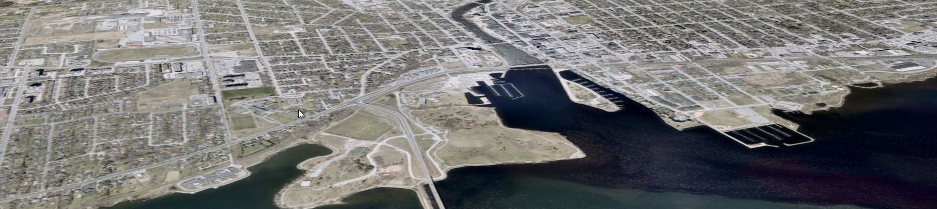
Map of Study Area |
|
The Loyalist (West Belleville) Secondary Plan area encompasses approximately 950 hectares (2347 acres) of land located east of Wallbridge Loyalist Road, south of Highway 401 and north of the Bay of Quinte. |
 Questions and Answers - Loyalist (West Belleville) Secondary Plan Update
 Project Overview and Timelines
 Public Engagement
 Latest Updates and Next Steps
Contact
To submit comments or be added to the interested parties list to be notified of the progression of the Loyalist (West) Secondary Plan update and when public engagements will be held please fill out our Loyalist Secondary Plan Update comment form or email planning@belleville.ca.